


 Canyon the only tourist canyon in the Fagaras Mountains")


 – Apuseni mountains")

 – deepest cave in Romania")


 Castle from Hunedoara")


Mării Valley (en. The Valley of the Sea) is the ideal place for canyoning in Retezat Mountains, in the area of Western Jiu river.
For canyoning, this route is particularly different than others. It has a heavy flow rate even in dry season. The canyon is spectacular especially near the waterfall of 35 meters high.


Marii Valey is a brook found in Retezat Mountains. It is a tributary stream of Western Jiu river.
The heavy flow rate occurs due to the fact that the valley gets its water from the main ridge of the Retezat Mountains. All brooks in the glacial cauldron under the Papusa Custuri Peak, Custura Peak, and Marii Valley Peak are drained towards Marii Valley.

Anyone can visit the Marii Valley up to the 35-m high waterfall.
There’s a tourist path, and there are wooden stairs with rails in more exposed areas. The path is not marked. Still there are signposts with Marii Waterfall and Lazarului Waterfall (tributary of Marii Valley).


Canyoning Marii Valley – Retezat Mountains
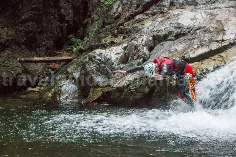
Covering Marii Canyon means descending six waterfalls of various lengths. The biggest and most impressive waterfall is 35 m high. At the base, the waterfall has a wonderful jumping pot.
Since the water from the canyon stems from high altitude melted snow, its temperature can be quite low.

The advantage of covering Marii Valley Canyon is that you can retreat or enter the canyon near any waterfall. For this reason, the canyon can be covered by both novices and experts.
Marii Valley is one of the few places where you can canyoning in Retezat Mountains.
 Access: from Petrosani > Lupeni > Uricani > after about 5 km from the exit from Uricani, follow the signpost with “Buta Lodge” on the right side of the road (Pay attention! NOT “Buta Tourist Resort” – they are two completely different locations).
Follow the forestry road another 3 km until you reach a Y-intersection.


Steer right following the Marii Valley/Lazarului Valley signpost. Another 100 m and you will have to park your car. You can get here by any type of car. The road can be easily covered.
Travel on foot from here, carrying your necessary equipment. You will reach a second intersection. From where you will follow the valley on the left (there is a signpost with Marii Valley).

Hike on the tourist path until you reach the base of the 35 m high waterfall.
In order to get to the upper part of the canyon, you will have to detour the waterfall on the right side (ascending). The path is quite trodden. It should be easy to find it.


For those who don’t want to waste too much energy, you can travel by car, but you will have to drive an off-road car.
On the first intersection (where you have taken right) continue on the left forestry road. After a while the road will cross Marii Valley through a bridge. You will descend the valley on foot until you reach the entrance of the canyon.
This alternative is not practical unless you have a driver who can drive it well aslant.
The TGR team covered the entrance to the canyon on foot.
 Recommended period:
We suggest covering the canyon in July-September for a smooth trip. During spring, the water flow is heavy due to the snow melting in Retezat Mountains. The discharge is too strong at the 35 m high waterfall and descending the waterfall should be done only by experts.

Necessary group equipment: 70 m cord, 25 m cord (for the smaller waterfalls), carabiners with lock, first aid kit. It’s important that the ropes to be marked at the middle.
Individual equipment: full wetsuit (trousers, jacket with hoodie, socks, gloves), harness with two lanyards, descending device, whistle, helmet.

Canyoning in Marii Valley (Retezat Mountains)
The canyoning area starts at about 50 m before the first waterfall.

Here you will find a small fall that has a beautiful pot surrounded by rock walls at the bottom. You can jump from the edge of the pot.

Don’t forget that the first member has to investigate the bottom of the pot lest somebody should get hurt. Those who jump inside can hit logs or rocks brought by the strong water.
The morphology of the canyon can change from one trip to another. Don’t rely on the fact that you tested it at one previous trip.

Waterfall 1 – is as 3 m fall which can be detoured to the right (downwards). It’s equipped with plates, chains, and ring on the left wall. You can get used to the water by descending this fall.

We continue on the water stream. There’s another 2 m fall. You can descend through the right part of the valley or you can use the same anchors mentioned before by using the longer cord.

Waterfall 2 – is about 8 m long. The anchors are found on the left side of the valley. You will find mooring with plates and rings.
If the water flow is weak, you can directly descend from the first two moorings. The rope has to be mounted only to the face of the water. The water level from the pot found at the base of the waterfall is higher than a person’s height. You can regroup after this waterfall.


Waterfall 3 – is the tallest one. The canyon is equipped on both versants.
Right side mooring: anchors were set here in 2015. At the traverse line you will find two intermediary mooring points.
The head of the waterfall will steer you laterally from the water flow.


At the head of the waterfall you will find three moorings because it was wanted to make a zip line here. The descent will get you on the right side of the pot at the base of the waterfall.
Visual contact can be established between the two members set on the descent.

Left side mooring: there are no anchors for the traverse line. The head of the waterfall is impractically positioned. You cannot establish visual contact with your team members. You can’t see if they reached the base of the waterfall or not. The first to descend has to pay extra attention especially since s/he has to traverse the pot at the base. It is quite deep and the water current is strong.
You cannot use auditory signals since the noise from the waterfall is too loud.

For safety reasons, we suggest using the anchors on the right side of the valley.
At the base of the 35 m waterfall, from the pot, you will have to descend again.
There’s a slide with a 5 m elevation gain. You can descend it without a rope on the right side. The rock is slippery, so you have to pay attention.
If you wish to use a rope, there’s a mooring – plate and a ring.

At the base of the descent there is another pot in which you can jump from about 1 m above it. Don’t forget to investigate the bottom of the pot before jumping.

Waterfall 4 – is a 7 m vertical. You will descend it using a tree found on the left versant as your mooring. You won’t descend through the water jet. You will have to put the rope till above the water from the pot since the water level inside it is quite high.

On getting out of the pot, you will see that you will have to descend without rope about 1.5-2 m. You can mount a rope if you want to – there’s a piton with a ring.
After this waterfall you made it on the tourist path.


Waterfall 5 – is a 5 m vertical. The fall is found near the wooden stairs that help tourists ascend towards the big waterfall. The moorings are made of two plates set on the right side of the valley. You will have to leave your two carabiners in the plates until you descend. You will get them if you hike back up the path. The length of the rope has to be above the water. There’s a deep pot at the base of the waterfall.
Waterfall 6 – is a 6 m vertical. You descend it using a tree found on the left side of the valley as mooring. The descent is done laterally towards the water jet. Owing to the pot, the descent is well worth the trip.
Pentru versiunea in limba romana
![]()
 – the heart of the Apuseni Mountains")